March 24 Tree Removals
UPDATE 4/2/2025
Tree removal has begun in the project area and is anticipated be completed by the end of the week, weather permitting. As a result of the March 20 onsite meeting with residents and neighbors, City staff completed an additional reassessment of trees on Parkview and Ivy for construction impacts and their chance of survival. No modifications were made by the Saint Paul Forestry Division, and all marked trees remain slated for removal because they are in poor health, are being impacted by the project, and/or considered a liability, safety concern, or are at the end of their useful life as determined by city arborists and engineers. Tree replacement remains a critical component of all city reconstruction projects to preserve our urban canopy in Saint Paul.
UPDATE 3/24/2025
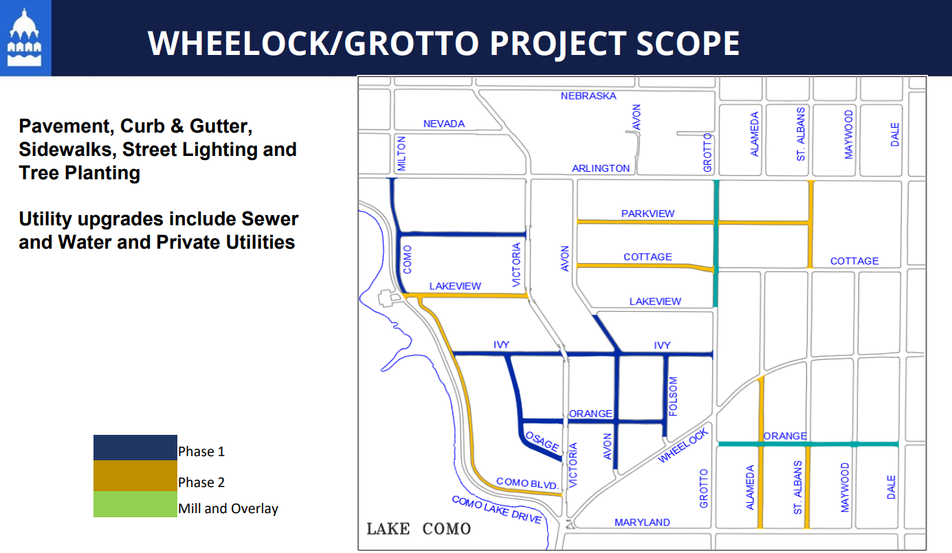
The Wheelock-Grotto Reconstruction project will fully reconstruct several streets in the neighborhood that were estimated to have been built in the 1920s and are long overdue for reconstruction work. The project includes installation of new sidewalks and curbs, making the neighborhood more walkable and accessible for everyone. The entire area lacks proper storm water drainage and requires much needed infrastructure updates to improve the water quality of Como Lake. The current underground water and sewer mains servicing the area are almost a century old and need to be replaced.
On March 20, 2025, Saint Paul Public Works and Parks’ Forestry Division staff met on site with a group of residents to answer questions about trees impacted by the Wheelock-Grotto Street Reconstruction project along Parkview and Ivy Avenue. During this meeting, the city’s survey crew agreed to mark property lines and new sidewalk installation areas on Parkview and Ivy avenues to help residents better visualize the potential construction impact areas. City staff also agreed to re-evaluate certain trees for construction impacts and their chance of survival. Marked trees would be slated for removal because they are in poor health, are being impacted by the project and/or considered a liability, safety concern, or are at the end of their useful life as determined by professional city arborists and engineers. Tree replacement is a critical component of all city reconstruction projects to preserve our urban canopy in Saint Paul.
City staff have had previous conversations with many residents to discuss the various impacts construction activities can have on adjacent boulevard trees. Curb installation, road/boulevard regrading, utility work, sidewalk installation, and other nearby construction activities may disrupt root systems of nearby trees. Construction impacts, especially to the root system, may not be immediately visible to the tree as a whole but do impact the tree’s health and stability and will only worsen over time. Saint Paul has a tree replacement plan that will re-vegetate the neighborhood with a diverse variety of boulevard trees providing a more resilient ecosystem.
Trees initially marked for removal on both Parkview and Ivy avenues from Como Boulevard to Victoria Street will not be removed until they have been re-evaluated by the city.
3/19/2025
On Monday, March 17 Public Works conducted a "tree walk" with Forestry staff to do a final assessment of the trees in the construction area. Trees were marked for removal with a red X in preparation for construction in the Wheelock-Grotto Phase 1 area. Tree removals are anticipated to start on Monday, March 24. As with all construction, schedules may change.
Trees were marked for removal for several reasons:
- Proximity to installation of curbs and/or sidewalk
- Underground utility work conflicts, including lead water service replacement, sewer, and water main installation
- Roadway regrading conflicts with root systems of existing trees
- Overall tree health condition including any pre-existing signs of decline and/or structural defects
Construction activities can be damaging to adjacent boulevard trees. Curb installation, road/boulevard regrading, utility work, sidewalk installation, and other nearby construction activities may disrupt root systems of nearby trees. These root impacts can make a tree unstable, creating a possible public safety hazard. These construction impacts may not be immediately visible to the tree as a whole, but do impact the tree’s health and will only worsen over time.
What to expect during tree removal:
- Roads will be temporarily closed at the locations where trees are being removed
- Road closures will move based on where tree removals are occurring
- Expect to see "Road Closed to Thru Traffic" and/or "Local Traffic Only" signs
Tree stumps will be left and removed during the road construction. New trees will be planted in the boulevard once construction is completed.