Description
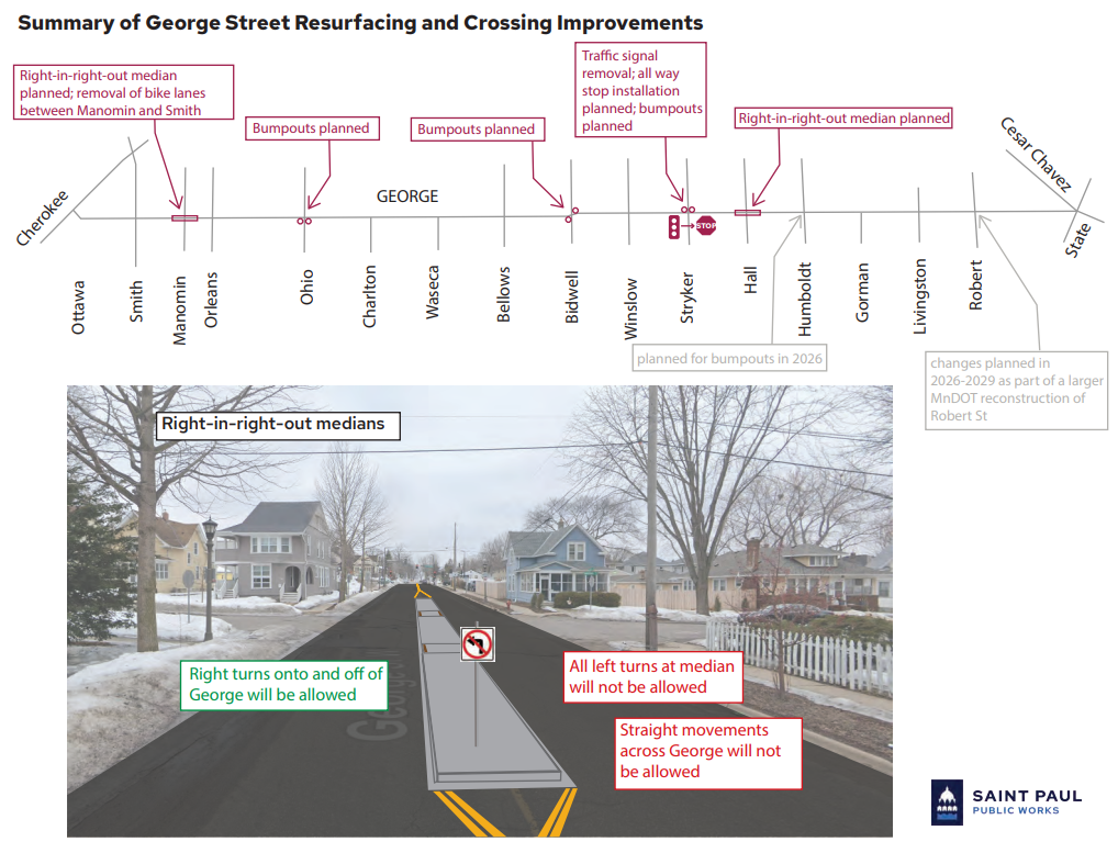
George Street from Cherokee Avenue to State Street will be resurfaced in 2025 through a process called mill and overlay to create a smoother roadway surface. Crews grind off the top layer of roadway, then replace it with a new layer of bituminous pavement. The project will include pedestrian and crossing improvements:

  • New pedestrian curb ramps will be constructed at intersections where needed. These will make walking or rolling along and across George Street easier.

  • Bumpouts (or curb extensions) and pedestrian refuge islands will be constructed at some intersections to improve safety for people walking and biking.

  • The traffic signal at George Street and Stryker Avenue will be removed and replaced by a new four-way stop.

Location
George Street from Cherokee Avenue to State Street

Timeline
2025

Tags

    Join us: Community Meeting April 9

    Join us to learn more about the proejct. Stop in any time to talk one-on-one with project staff and ask questions. 

    Wednesday, April 9, 2025
    6:00 p.m. – 7:30 p.m. 
    Riverview Library (meeting room in basement) - 1 George Street E, Saint Paul, MN 55107

    Planned Pedestrian and Crossing Improvements

    The changes described below are proposed based on community feedback, prior planning (the West Side Safe Routes to School Plan and the Saint Paul Bicycle Plan), and technical input from city staff. The goals of these changes are to slow drivers, provide better visibility of people walking and biking, and reduce the crossing distance for people walking. Changes will be made at the following intersections: 

    Ohio Street 
    Bumpouts (or curb extensions) will be added on the south side of the street to improve visibility of people crossing George Street, reduce the crossing distance for people walking, and slow drivers by narrowing the street. There will also be bumpouts into Ohio where possible. 

    Bidwell Street 
    The intersection of Bidwell Street and George Street has a unique curve. Bumpouts will be added to help address this curve and better align drivers, while also improving visibility of people crossing George Street, reducing the crossing distance for people walking, and slowing drivers by narrowing the street. 

    Manomin Avenue and Hall Avenue 
    A pedestrian refuge island (median) will be added on George Street at both intersections to help slow drivers and provide people walking and biking a place to pause and cross each lane of traffic separately. Both Manomin Avenue and Hall Avenue are recommended bicycle boulevards in the Saint Paul Bicycle Plan. Installing medians will give people biking north and south a more comfortable crossing of George Street, and also reduce the number of vehicles on both Manomin Avenue and Hall Avenue. 

    The medians at Manomin Avenue and Hall Avenue will not allow left turns onto or off of George Street. Traffic will not be able to cross George Street at Manomin Avenue and Hall Avenue (eliminates north and south movements). Traffic will still be allowed to drive along George Street (allows east and west movements) and turn right onto and off of George Street. 

    Stryker Avenue 
    The existing signal at George Street and Stryker Avenue is outdated and will be removed. The amount of traffic on George Street and Stryker Avenue does not meet current standards for replacing the signal with a new one. Instead, a four-way stop will be installed and bumpouts will be added to the north side of the street.  

    Map showing the crossing improvements along George Street and an example of a center pedestrian median that does not allow left turns

    Previous and Current Planning

    When the city has an opportunity to invest and imprive streets, staff look to previous planning that has identified issues or ideas. There is some current and recent work that is happening on the West Side that staff will reference for the resurfacing of George Street:

    • The City of Saint Paul Bicycle Plan (April 2024) does not recommend a bikeway (space for bikes) on George Street, but Manomin and Hall are planned bike boulevards (see the Planned Bicycle Network map on page 9). This resurfacing project will consider ways to improve the crossings of Manomin and Hall, at George. 
    • The West Side Bicycle Boulevard Vision Plan is exploring ways to improve all planned bike boulevards on the West Side, including Manomin and Hall. 
    • The West Side Safe Routes to School (SRTS) Plan (2021) was created by Saint Paul Public Schools. It identifies challenges to walking and biking to schools on the West Side. The recommendations include improvements on George Street. This project will reference the SRTS Plan. 

    Project Documents