Project Overview

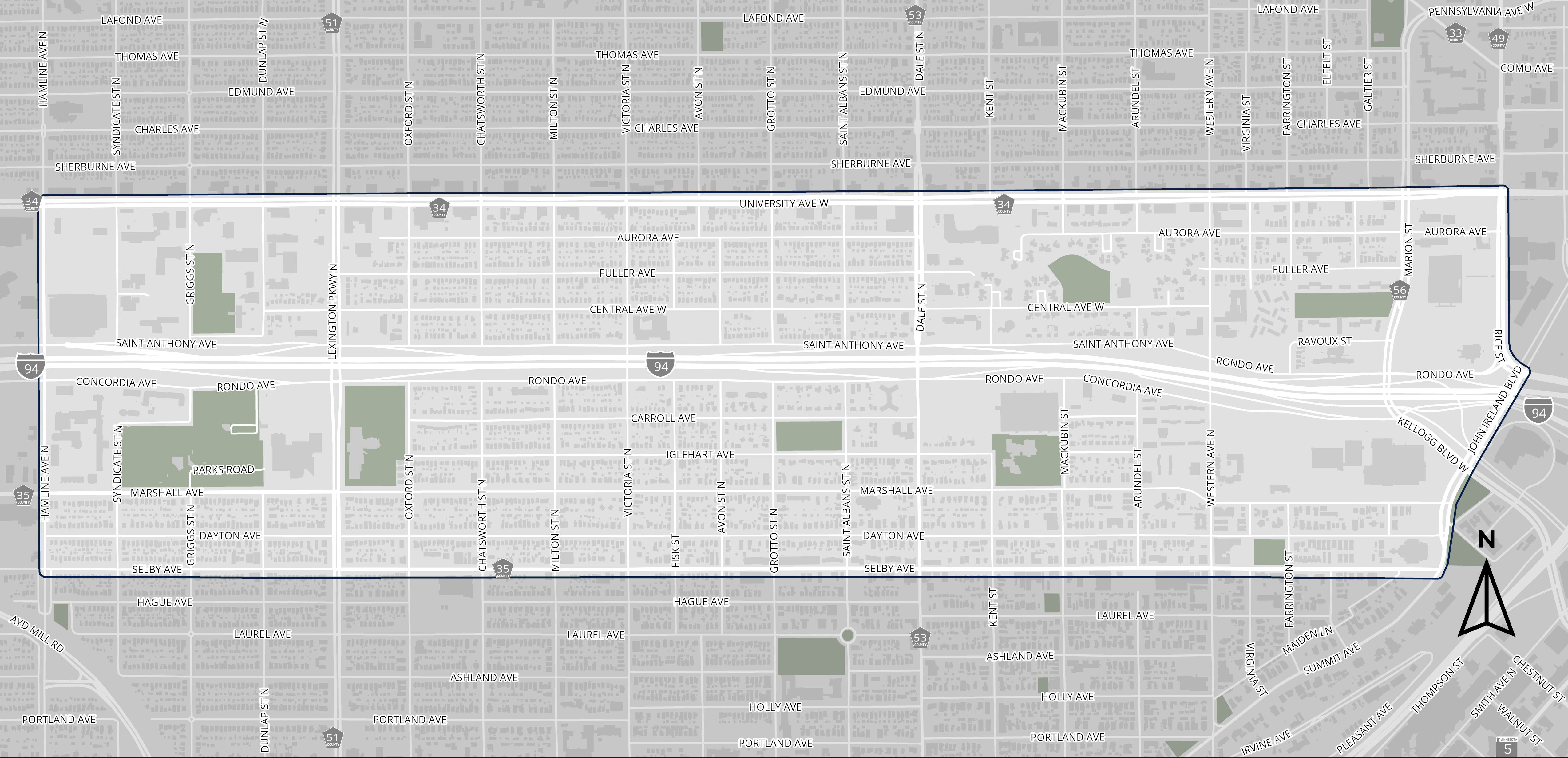
The City of Saint Paul is developing a community-led vision for street improvements within the Rondo neighborhood and adjacent areas. The study area includes city-owned streets, sidewalks, boulevards, and public right-of-way from Hamline Avenue to John Ireland Boulevard/Rice Street and from University Avenue to Selby Avenue. This is a planning study that will be used to inform future street construction.

Print and share information about the Rondo Streets Study

Study Area

Map showing the Rondo streets study area

Share Your Vision for Rondo Area Streets

Feedback is critical to creating a community-led vision for street improvements within the Rondo neighborhood and adjacent areas. 

Take our survey to share your vision of what the streets in the Rondo neighborhood could look like in the future. 

Share your location-specific feedback about what you currently experience when traveling in the Rondo area and what your vision is for the future of streets and travel in the Rondo neighborhood. To leave a comment on the map, click the "Points" tab on the top of the screen, select the type of comment, click the map at the desired location, and type your comment.

Project Goal 

Engage residents and businesses in the Rondo area in an authentic way to gather critical input and information to build a community-supported plan for how the city will rebuild the streets and public infrastructure in the area.

What will the final plan from this study include? 

  • The plan will represent and be supported by the Rondo area residents and businesses. 
  • Community-supported conceptual designs for neighborhood streets to be implemented with future construction. 
  • An implementable vision, informed by community feedback, which makes walking, biking, rolling, accessing transit, and driving in the Rondo area safer and more comfortable. 
  • Apply the city’s policies and goals as reflected in the 2040 Comprehensive Plan, Bicycle Plan, Pedestrian Plan, Transportation Safety Action Plan, and the Climate Action & Resilience Plan.

How will the city work with the community? 

  • Ask questions, listen, and document issues and concerns from community members to develop a community vision for the neighborhood. 
  • Report back and share all collected input and feedback, including concerns and opposition to specific suggestions for use of the public spaces. 
  • Explore different ideas for how to use the public spaces, including streets, sidewalks, and boulevards.
  • Empower BIPOC residents, business owners, and community organizations throughout the decision-making process.
  • Share how technical data (racial equity, health, and economic impact assessments) are helping to inform the planning study.
  • Continue ongoing conversations with community members throughout the planning study. Explore different ideas for how to use the public spaces, including streets, sidewalks, and boulevards. 

Timeline

Rondo Streets Study time from Fall 2024 to winter 2025

Coordination with Other Work in the Area

The Rondo Streets Study will coordinate work with other projects in the area, including, but not limited to: MnDOT Rethinking I-94, ReConnect Rondo, Summit-University Planning Council, and Union Park District Council. When possible, this study will build upon and alongside other neighborhood planning efforts.

Project Documents

Last Edited: March 28, 2025