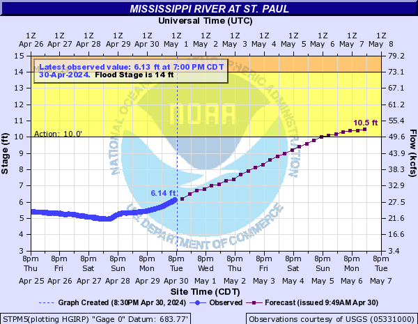
Flood Forecast from the National Weather Service
For the most up to date flood forecasts, and updated flood forecast view, please visit the National Weather Service website.
Last Edited: April 1, 2026
For the most up to date flood forecasts, and updated flood forecast view, please visit the National Weather Service website.
City of Saint Paul Emergency Rehab Loan Program – Low- and moderate-income homeowners who owner-occupy & homestead their property located in Saint Paul might be eligible for an emergency rehab loan. The loan is 0% interest with a 15-year term, forgiven at 1/15th annually. Eligible homeowners can get up to $40K to be disbursed directly to contractors once work is complete. Submit an intake form to see if you qualify.
Minnesota Housing Fix Up Home Improvement Loan Program – This state program offers fixed interest rate financing in amounts $2K-$75K for a term of 1-20 years. The program is designed to support with most kinds of home improvements and borrowers can perform the work on their own if already skilled in the trade needed.
Minnesota Housing Rehabilitation Loan Program – This state program assists low-income homeowners in financing home improvements that directly affect the safety, habitability, energy efficiency or accessibility of their homes.
Minnesota Housing Emergency & Accessibility Loan Program –This state program is available for home improvements that address emergency conditions of the home or accessibility needs for a household resident with a disability.
Non-profit organizations that provide free or low-interest resources for low- to moderate-income homeowners & renters
Energy Cents Coalition (1-4 units)
Multifamily Energy Solutions by CenterPoint Energy & Xcel Energy (5+ units)
Community Development Finance Institutions (CDFIs)
Contractors
Emerging and small businesses, and enterprises owned by women and minority communities.
Consolidated across Saint Paul, Minneapolis, Hennepin County, and Ramsey County to centralize contractor opportunities.
U.S. Dept of Housing and Urban Development guide on fixing up your home (provided for contractor due diligence tips, ignore FHA financing details at end)
City of Saint Paul Fire Department Project Safe Haven
Saint Paul Regional Water Services (SPRWS) Lead Free Saint Paul program
Xcel Energy wants to help your family stay safe in the event of flooding. It’s also taking steps to ensure its facilities can continue delivering reliable service if flooding occurs.
If flooding happens in your area, to help keep you safe, Xcel Energy may need to disconnect electric or natural gas service to some customers. You should not attempt to disconnect electricity or natural gas service yourself.
Visit Xcel Energy’s website to learn more about flood safety and preparations, or contact their Customer Care representatives at 800-895-4999.